
Abstract
Because traffic congestion often has impacts on safety, visitor experience, resources, emergency response times, and park operations, reducing congestion is an important management topic for Acadia National Park. This project explores the use of remote webcams to monitor parking lots and other areas of interest within the park, with the ability to upload images in real time to the Acadia Park website where they can be viewed by the public and Acadia management personnel. This strategy is being explored to help mitigate traffic congestion.
Acknowledgements
Our team would like to thank the many Acadia National Park Rangers who helped us with our project. Thank you to Jay Elhard for showing us around the North Atlantic Coastline Webcam and for providing technical details on the park web infrastructure. We would like to acknowledge Ranger John Kelly for providing us with the information of road closure and congestion statistics. We would also like to send thanks to our liaisons, Science Coordinator Abe Miller-Rushing and Conservation Director Stephanie Client, for giving valuable feedback about our implementation of the static webcam. We are also appreciative of all the support from other park staff members as well as staff from Friends of Acadia. Also thank you to the College of the Atlantic for providing housing.
At last, we want to express our sincerest thanks to our professors Frederick Bianchi and Balistrieri, Thomas J. Professor Balistrieri gave us some enlightening ideas and helped us work through the social science part of this project. Professor Bianchi was a responsible and brilliant advisor for guiding us through all the difficult and confusing times.
Executive Summary
Recent years have seen a massive expansion of visitation to Acadia National Park. In an attempt to control this influx, Acadia National Park has developed a traffic management plan, part of which requires monitoring of traffic to establish the effectiveness of their plan. To assist in the completion of this goal, we investigated a variety of autonomous webcam related systems that could be used in a number of ways to actively and passively monitor conditions within the park.
Project Goal
The goal of this project was to develop a comprehensive webcam system for monitoring the road conditions and sending back the images on websites. For park rangers, this system can help gather real-time information as an indicator of critical congestion. For visitors, they can check the current and past road conditions as a reference for planning their trip. To achieve this goal, we created a solar-powered cellular static webcam and proved that this system can continuously work in the field with minimal maintenance. We also proved the concept of a GPS activated mobile webcam system which will automatically capture images at chosen GPS coordinates and automatically upload them to a web server. In addition, a proposal design is made to demonstrate the functions of a potential web page for the use of park rangers and visitors. The primary objectives of this project were to:
- Design, develop, and construct a fully self-contained webcam system ready for deployment in the national parks.
- Implement the static webcam via installation at a location of key importance within the park.
- Design, develop, and construct a prototype mobile webcam system capable of wide-area coverage.
- Verify the concept of a mobile webcam system by conducting field tests throughout key locations in the park.
- Create a prototype web page design to display the images collected from both the static and mobile camera platforms in real time, as well as providing access to historic images.
- Evaluate the results of the previous objectives, and offer a set of recommendations for how park staff as well as future WPI projects should continue work on this subject.
Development of Methodology
In order to achieve the goals presented to us, we explored a number of methods. Development of the technical outlines for the static webcam system was undertaken with the understanding that it would need to operate under a variety of weather conditions. Many specific requirements for the static camera platform were resolved by the 2018 Acadia National Park Webcam Research Group, including the ability to operate for multiple days under adverse weather conditions.
In addition to the static camera, we investigated the unique requirements of effectively capturing data from a large number of locations which may feature little to no connectivity. An investigation of cellular connectivity conducted by the 2018 Cellular Connectivity group showed that there are many locations in the park which feature absolutely no 4G/LTE connectivity, despite containing regions of potential interest. Internal discussions resulted in the decision to implement a mobile platform for capturing the images upon the Island Explorer bus network. This allowed the camera to reach dozens of points throughout the park, including those without reception by caching the images internally for upload at a later date.
The final methodology was to create a web interface to enable members of the public and park administration to view present and historical information from the cameras. Previous commercial solutions did not permit public access to image data, and severely limited access to authorized personnel. This necessitated the creation of an accessible and intuitive interface.
Potential Impact of Methodology
This project provided the technological framework for a complete static camera based monitoring system to the National Park Service, which can be used to assist in the key monitoring aspects of Acadia National Park’s transportation plan. If sufficient developments are made into a large-scale deployment of this technology, park staff will be able to actively monitor important locations in the park.
The static camera methodologies were created with the intent that park would explore options for third party contractors to perform the final implementation across the park. The development and implementation of the static camera proved that it is not only possible, but feasible to implement and deploy an autonomous wireless camera system in the park, and gather valuable information from it.
The mobile camera methodologies were created to demonstrate the value of future research into the topic. While we were able to capture and upload images consistently from test vehicles, additional research will be required into the subject before a set of final recommendations can be offered.
The website methodology produced a design for an interactive website that could be used by both visitors and park staff to obtain current and past information about traffic conditions throughout a wide area of the park. If converted into a fully interactive web application, it would provide intuitive access to thousands of present and historical data points.
Based on all the images and data evaluation, we offered recommendations from three perspectives: equipment improvement, image analysis, and park implementation. We recommended that the battery capacity should be doubled for a long-term use; For specific locations a point-to-point Ethernet bridge could be a preferred choice for data transmission; A rebooting function should be added into the static webcam system for significantly saving power. We also suggested that image recognition AI should be conducted to improve the efficiency of the monitoring system and automatically extract valuable information. Lastly, we pointed out that the park could consider sending a Request For Information followed by a Request For Proposal, and select a qualified third party company for further development and maintenance.
1.0 Introduction
Visitor and traffic congestion is a major problem experienced throughout the entire National Park system. In 2018, approximately 318 million people visited national parks (National Park Service [NPS], 2019). Congestion within the parks is experienced in parking lots, hiking trails, visitor centers, and various major attractions. (NPS, 2018a).
Acadia National Park, located in Maine, also suffers from visitor and traffic congestion. In 2018, approximately 3.5 million people visited Acadia National park. In that year, the park ranked seventh on the most popular national parks list (National Geographic, 2019). Compared to most other National Parks, Acadia National Park is rather small in size, comprised of only 49,705 acres of land. The Park is ranked 47th out of 60 national parks by area (NPS, 2018b). However, it is one of the most popular national parks in the United States. As a result, visitor density in Acadia National Park is very high leading to the problem of visitor and traffic congestion. A study by Resource Systems Group shows that from August 1st, 2015, to September 29th, 2015, Acadia National Park was visually crowded every day and physically crowded 80% of the time. Visual crowding means there are at least eight people per views cape and physical crowding means there are at least fifteen people per views cape (Resource Systems Group, 2017).
The National Park Service released the Final Transportation Plan and accompanying Environmental Impact Statement (FTP/EIS) on March, 2019 for Acadia National Park, which aims at providing safe and efficient transportation to visitors and protect park resources and values. Some key actions including creating a reservation system, expanding the public transit service, and setting indicators and thresholds would be implemented to improve traffic conditions. Establishing a comprehensive monitoring system would be a critical component for providing references to those indicators and ensuring that the amount of visitor use will not exceed the maximum capacity. The goal of this project was to develop a comprehensive webcam system for monitoring the road and parking lot conditions and sending back the images on websites. For park rangers, this system can help gather real-time information as an indicator of critical congestion. For visitors, they can check the current and past road conditions as a reference for planning their trip. To achieve this goal, we created a solar-powered cellular static webcam and proved that this system can continuously work in the field with minimal maintenance. We also proved the concept of a GPS activated mobile webcam system which will automatically capture images at chosen GPS coordinates and automatically upload them to a web server. In addition, a proposal design was made to demonstrate the functions of a potential web page for the use of park rangers and visitors.
2.0 Background
Acadia National Park’s Final Transportation Plan (FTP) will be implemented with the purpose of improving traffic and parking conditions while ensuring the quality of visitor experience and natural resources are well protected. This project sought to verify the feasibility of establishing a comprehensive monitoring system to fulfill the FTP while including recommendations for Acadia National Park management. A key background review that describes park conditions, traffic congestion, FTP of Acadia National Park, and related issues was performed in the following sections.
2.1 Description of the Park
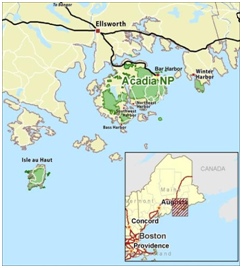
Acadia National Park is located across Mount Desert Island, the Schoodic Peninsula, Isle Au Haut, and many smaller coastal islands around Bar Harbor, Maine, some only a few meters across. About 30,000 acres are located on Mount Desert Island, constituting 60 percent of the total area of the park. Originally established in 1916 as the Sieur de Monts National Monument by Woodrow Wilson, its purpose was to protect the natural beauty along the Atlantic shore of the United States. In 1929, the park was renamed to Acadia as a condition of a large private land donation on the Schoodic Peninsula. Figure 1 below shows the location and scale of Acadia National Park relative to Mount Desert Island and the State of Maine.
Even though the park has received many land donations throughout history, today it still remains one of the smallest National Parks with an area of fewer than 50 thousand acres. Despite this, it is one of the ten most popular national parks, with the number of visitors increased by 58.8 percent since 2009 to a staggering 3.54 million with most attending between the months of June and September (NPS, 2019c). Visitors can enjoy recreational activities including viewing the scenery, hiking, camping, bicycling, and canoeing. Within the park, several locations including Cadillac Mountain, Sand Beach, and Jordan Pond make up the most popular attractions, drawing the bulk of visitors, and directly contributing to the congestion issues which currently plague the park (NPS, 2019).
2.2 Traffic Congestion and Safety Concern
As Acadia National Park has become more popular, the existing road infrastructure has begun to struggle with the number of visitors attending each year. Many of the roads, constructed as many as one hundred or more years ago have become overwhelmed with recreational vehicles, pedestrians, cyclists, the Island Explorer and tour busses. This poses a serious threat to visitor safety, as emergency vehicles can become encumbered while attempting to navigate through masses of illegally parked vehicles in route to the scene of an emergency site. The massive overcrowding of vehicles also detracts greatly from visitor experience, forcing visitors to wait for traffic, skip attractions, or park illegally.
As annual visitation rates have continued to rise over the past 28 years, the parks limited infrastructure has been forced to withstand 51% more traffic, contributing to an exponential increase in congestion (NPS, 2018a). In 2005, the park experienced just over two million visitors, however by 2018 that number had increased to nearly 3.6 million.
Previous research into the subject of traffic congestion in Acadia is plentiful, having been the topic of numerous academic analyses over the past 20 years. In “Preparing Acadia National Park for Modern Tourist Congestion”, it was determined that traffic congestion posed a serious issue during several peak time slots in which the number of visitors could increase by as much as 600% in less than an hour. (Cosmopulos, Gaulin, Jauris, Morisseau, &Quevillon, 2017)
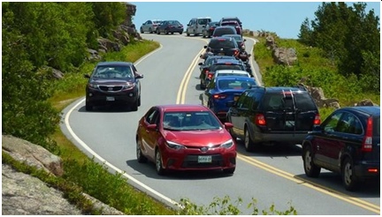
One major contributing factor to the congestion is the intrinsic link between automobiles and the National Park Service. For many visitors to the park, “[Taking an] ocean Drive is important because it allows access to and enjoyment of the scenery” (Hallo & Manning, 2009). In total, 96% of surveyed respondents claimed that driving was an important part of the park experience (Hallo & Manning, 2009). With visitor traffic increasing at an ever greater rate, and the great American pastime of driving not predicted to go anywhere anytime soon, congestion is only projected to get worse unless something is done. Cadillac Mountain is the most crowded point for visitors to Acadia National Park since visitors can enjoy magnificent views of dotted island landscape from all directions. Cadillac Summit is only accessible through a twisting and narrow road which is closed from December to April. Studies indicated that 75% of visitors went to Cadillac Mountain Area during their stay (Monz et al., 2010). Between June 2,2016 and October 31,2016, about 259,000 vehicles and 777,000 visitors went to Cadillac Summit (Charles Jacobi, 2016). The road to the summit was closed 70 times in 2017 due to congestion issues (Kong & Ring, 2019). Figure 2 below shows the traffic congestion of Cadillac Summit Road.
2.3 Final Transportation Plan
Since the congestion problems created safety issues, natural and historic resources protection concerns, and adverse impacts on visitor experience, the National Park Service (NPS) released the
Final Transportation Plan and accompanying Environmental Impact Statement (FTP & EIS) on March, 2019 for Acadia National Park (NPS, 2019a). The FTP aims at giving a comprehensive approach to provide safe and efficient transportation to visitors and protect park resources and values. The following are the key actions related to project.
Reservation Systems: One of the most critical actions undertaken by NPS in regards to traffic congestion is the reservation system. The purpose of the reservation system is to control visitor flow volume within the desired visitor capacities not including cyclists or pedestrians in popular scenic spots: Cadillac Summit, Thunder Hole, Jordan Pond, Sand Beach, Bubble Rock, etc. Reservations can be made online or through automatic service machines located at the Hulls Cove Visitor Center and the Acadia Gateway Center. The number of reservations or the duration of parking reservation for each location would be adjusted for each different time period to provide the best visitor experience by preventing traffic congestion and parking lot backups. If the volume of transit at specific location still exceeds set thresholds after the reservation systems for recreational vehicles are implemented, the reservation system could be extended to Island Explorer in order to manage traffic issues.
Public Transit: The Island Explorer service is a public transportation system with ten routes linking hotels, popular attractions (except Cadillac Summit), campgrounds, and visitor centers on Mount Desert Island and the Schoodic Peninsula (Downeast Transportation, 2019). Since the Island Explorer service cannot meet demands at peak volume of transit, increasing the number of Island Explorer buses becomes another important component of the Transportation Plan. The island explorer also does not travel to the summit of cadillac mountain, one of the parks most popular attractions and sources of traffic congestion. As described in the last section, Island Explorer service would also be expanded to cohere with the reservation systems requirements.Visitor Information: The National Park Service plans to provide more varied and detailed information to visitors, both before and after they arrive at the park. That increased information includes reservation requirements and availability, trip-planning tools, orientation tips, advice on vehicle and bicycle safety, and car-free road sections. Information about traffic congestion and parking availability would be monitored and disseminated to the public, and it can be accessed online or through mobile applications. Additionally, the park will improve cellular connectivity throughout the park by cooperating with communication providers. With better cellular signal, visitors have the capability to receive more real-time information from the park as a reference for planning their trips.
2.3.1 Existing Monitoring Strategies in the Plan
The National Park Service would adopt the Visitor Use Management Framework created by the Interagency Visitor Use Management Council (NPS, 2019a). This Framework includes establishing indicators, thresholds, and determining visitor capacity, in which monitoring is used to track these conditions over time (Interagency Visitor Use Management Council, 2016). According to monitoring results, park rangers could adjust the management strategies to ensure that the amount of visitor use will not exceed the maximum threshold. The following list below includes several Monitoring Strategies that would be implemented in the plan.
Vehicles at one time (VAOT): VAOT is a measurement technique commonly used by park rangers to quantify the amount of vehicles in parking lots and right-lane parking (Manning, Lawson, Newman, Hallo, & Monz, 2014). VAOT will be used as an indicator of transit and access conditions at crowded attractions (e.g., Thunder Hole, Jordan Pond, Sand Beach, Bubble Rock, Echo Lake Beach, Cadillac Summit). This indicator would also ensure the visitors with reservations of parking lots can arrive at their intended destinations as assigned.
People per Viewscape (PPV): PPV is a measure that helps park managers to quantify visitor crowding impacts along hiking trails, walking paths, and other scenic corridors in national parks (NPS, 2019a). PPV will be monitored on at least one of the following higher use trails: Jordan Pond Path, Beehive Trail, South Bubble Trail, Wonderland Trail, Cadillac Mountain Gorge path, Schoodic Head Trail (NPS, 2019a).Automated vehicle traffic recorder (ATR): ATRs are devices for collecting large amounts of traffic volume data. ATRs can measure the direction of flow, traffic speed, and other crucial variables through pneumatic tubes (Accu-Traffic inc., 2010). Based on ATR data, NPS plans to establish statistical and mathematical relationships with other indicators like VAOT, vehicles percent time following, and PPV for visitor use management.
2.3.2 Webcams as Additional Monitoring Strategies
The monitoring strategies which would be implemented in the Transportation Plan are all measurable attributes (e.g., VAOT, PPV) that can help park rangers to make changes in resources and conditions related to visitor experience. However, these data cannot . Therefore, webcams in various parking lots are more effective at determining current congestion situation. The real-time images been sending back from webcams can shorten the reaction time for appropriate managerial decisions.
2.3.3 Webcams as Information Provider
The Nation Park Service currently provides some basic information (operating hours, weather, closure conditions, fees, park regulations, etc.) to visitors for planning their trips. As described in the ‘Visitor information’ section of the Plan, the National Park Service sought to provide more information about congestion and parking availability and enhanced trip-planning tools to visitors. Webcams are a great information source by uploading real-time images to the public website so that these images can be accessible to the public. With better cellular connection in the future, visitors could browse the conditions of road and parking lots of all the attractions upon arrival so that visitors can adjust their schedule to avoid traffic congestion. By providing this information, visitors would have a more comprehensive picture of the transit conditions of the park by browsing images of previous years before they arrive at the park.
2.4 Related Project Overview
2.4.1 Previous WPI Projects
Our project is an extension of the 2018 Acadia Webcam IQP. In 2018, they explored the “Feasibility of Webcam Implementation in Acadia National Park”. In this project they benchmarked the webcams used in Yellowstone National Park and decided to experiment with webcams as a solution for the traffic congestion situation in Acadia National Park. In order to prove this idea is feasible, they also did research on the cost of webcams as well as the visitor rights and ethics associated with surveillance technology. It turned out that webcams were not expensive and monitoring in the park was unlikely to be a violation of privacy rights. Thus, they utilized the Spypoint Link-S camera to take pictures in fourteen locations throughout the park and successfully got decent pictures. After determining the camera’s battery performance, cell signal and picture quality, they concluded that “a webcam could be a reliable tool to remotely monitor traffic in parking lots” (Bruno, Cromwick, &Feng, 2018). They also suggested the connectivity and power source might be a limitation that need to be worked on. Besides the 2018 Acadia Webcam Team, this project also took the works from 2018 Acadia Cellular Connectivity Team and 2018 Glacier Congestion Management Team as references. The 2018 Acadia Cellular Connectivity Team measured cellular connectivity status in Acadia National Park. They recorded the cellular signal strength and internet speed of different providers throughout the island. The final cellular signal heat maps suggested AT&T is the most reliable and consistent signal provider on Mount Desert Island (Bergquist, Palacios, &Goklevent, 2018). Additionally, the 2018 Glacier Webcam Team explored the feasibility using a Raspberry Pi as the platform for the webcams. They also demonstrated the feasibility of using File Transfer Protocol over a cellular connection (Barrameda, Vose, & Rizzo, 2018). This allowed the pictures taken by the webcams upload to a website directly.
2.4.2 Existing Cameras in Acadia National Park
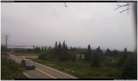
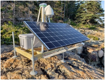
At present, only one webcam placed at North Atlantic Coastline is working in Acadia National Park (as seen in Figure 4). This camera funded by Canon aims at “Offering glimpses of sunrise, storms, sailboats, and the occasional seagull” (NPS, 2018c). A static image is taken every minute and published online through cellular data connectivity by daylight. The Camera is powered by a rechargeable battery and a solar panel, which ensures that the camera can work continuously.
3.0 Methodology
The goal of the project was to develop a comprehensive webcam system for monitoring the road conditions and uploading images to the cloud. For park rangers, this system can help gather real- time information as an indicator of critical congestion. For visitors, they can check the current and past road conditions as a reference for planning their trip. This project contains three main components: a static webcam intended for installation at a fixed location, a mobile webcam intended for installation on a vehicle such as a bus, and mockup websites. To achieve this goal, five subsidiary objectives were accomplished:
Objective 1: Design a static webcam system Objective 2: Implement a static webcam system
Objective 3: Verify the concept of mobile webcam system
Objective 4: Make a mock-up of web pages that will display the images from webcams Objective 5: Evaluate the data and offer recommendations
3.1 Objective 1: Design a Static Webcam System
This section describes the design goals, the process and analysis of how we determined the appropriate components of the system, how these components work together, and the cost of the system.
3.1.1 System Design Principles
This static webcam system seeks to achieve the following goals:
- Operate continuously for months with low maintenance in all weather conditions.
- Able to upload real-time, high-resolution images to public websites periodically.
- Self-contained power supply without grid connection
- Low cost compared to professional security camera
- Moderate size, easy to installed
3.1.2 Hardware Selection
In the beginning, we considered using the Spypoint Link-S, the one used by the webcam team last year to determine the feasibility of traffic monitoring in Acadia National Park. The SkyPoint Link- S is a solar cellular trail camera with supporting mobile applications and private cloud storage (Bruno, Cromwick, &Feng, 2018). With these accessories, users can easily set up the webcams and put them into use. However, it is not possible for us to make modifications and add components as needed since the Spypoint Link-S is not an open source system. Additionally, users have to pay monthly fees to get accounts to view the images. This means that the accessibility to those images is very limited because park rangers and the public would have to use one account. For these reasons, we decided not to continue with last year’s setup.

We chose the Raspberry Pi, a credit-card sized single board computer, as our central processor. Flexibility is the major advantage of this setup compared to the SkyPoint Link-S and other existing products. Since the Raspberry Pi runs a suite of open source software, it is easy to program as we need. With the matched camera module, we can adjust the size of the image and the time interval based on actual situations. The LTE (Long Term Evolution, a standard for 4G wireless broadband communication for mobile devices and data terminals) module gives SFTP compatibility to Raspberry Pi, which allows the images to be uploaded to public websites.
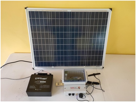
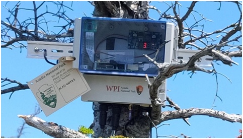
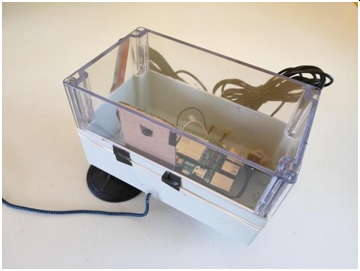
The power supply for the webcam system contains a battery and a solar panel used to charge the battery. We selected SLA1116 to be our test battery (12V, 18Ah). With this battery, the system could last approximately two and a half days without solar panel. Please refer to “Appendix A: Battery Estimation” for detailed calculations based on the power consumption. The 50W solar panel we chose is twice the power required so that the battery can be fully charged in a short period of time. A transparent weatherproof box is used to prevent electrical components from water and moisture. The battery and solar panel are also waterproof for the purpose of surviving in the field. When we were doing some tests prior to setting-up the device in the field, we noticed that some water drops could hang on the acrylic surface on rainy or foggy days. A hydrophobic coating spray was adapted to solve this issue while ensuring the camera’s view would not be blocked. The weatherproof box is shown in Figure 6 below.
3.1.3 System Structures
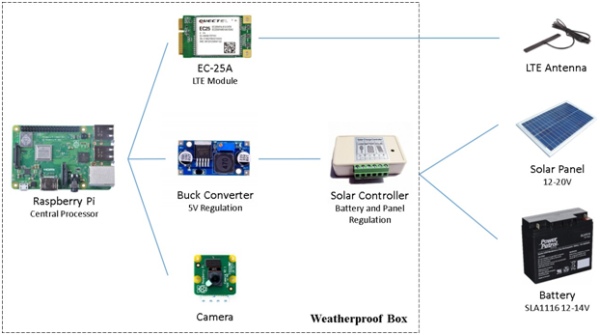
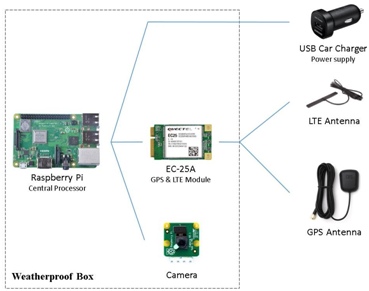
Figure 7 shown below introduces the main compositions and working principles of the static webcam system. As the central processor of the system, the Raspberry Pi is connected to the LTE module (EC-25A), buck converter, and camera. The LTE Antenna helps the system achieve better cellular connection at the summit of the mountain. The Buck converter is used to convert the 12V input voltage from the solar charge controller to 5V, the normal operating voltage of the Raspberry Pi. The Buck converter is connected to the solar controller, a small box consisting of solid state circuitry. Its function is to regulate the amount of charge from the solar panel so that the batteries will not be over or under charged. The weatherproof box contains all the components except the LTE antenna, solar panel, and battery. Figure 8 below shows key components of the system.

3.1.4 Cost of the Static Webcam
The total cost of the hardware components is about $350, which is relatively low compared with existing outdoor security cameras. These cameras usually cost around $600 to $1000. Additionally, the data plan carries a fee of approximately $50 a month to upload the images to the server. Please refer to “Appendix B: Static Camera Bill of Materials” for a detailed list of components including the quantity and price.
3.2 Objective 2: Implement a Static Webcam System
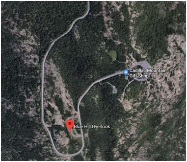
We put the camera at the Blue Hill Overlook on Cadillac Mountain. The reason for that is the serious over-crowded conditions on Cadillac Mountain. The summit road to Cadillac Mountain was closed 54 times in 2018 due to traffic congestion (Kong & Ring, 2019). By putting the camera near Blue Hill Overlook, we can not only see the traffic conditions at the entrance of Blue Hill Overlook parking lot, but also monitor the road for vehicular congestion back-up from the summit of Cadillac Mountain. On the other hand, the traffic conditions near the exit of Blue Hill Overlook is an important indicator to the summit of Cadillac Mountain. Occurrence of traffic congestion around this area indicates that the Cadillac Summit could exceed its visitor capacity, and the Cadillac Summit Road should be closed.
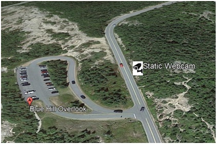
To achieve the goal of monitoring, a location with a wide view was required. Therefore, we did a field investigation. There were some high trees we believe might be the ideal location for the camera, but we had to consider the safety and equipment limitations. We finally decided on a relatively low tree which provided an acceptable view. Figure 10 shows the exact location of the static webcam. The camera itself was fastened to the trunk through two bungee cords. The solar panel was placed on branches and reinforced by nylon rope and studdles. The battery was semi- buried in the soil under the tree to protect it from environmental conditions. The final setup of our system is shown in Figure 11 below.
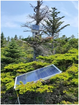
The webcam was programmed to take pictures from 4 a.m. to 8 p.m. In this way, the webcam could monitor from early morning and would not miss the crowd of people who came for sunrise or sunset. To transfer the images, a data plan of 18G from AT&T was bought and installed on the webcam. The time interval between two pictures was set to two minutes to optimize power and data usage. This number could be easily adjusted if necessary. Once the camera captured an image, it would automatically upload the image to a server that can be viewed online. The Figure shown below is an example photo taken by static webcam.

3.3 Objective 3: Verify the concept of a mobile webcam system
3.3.1 Design a Mobile Webcam System
After development and implementation of the static webcam platform was complete, we began investigating the possibility of using a GPS activated mobile camera platform for capturing images at a variety of locations. To do this, we utilized the Mobile Capture Platform developed in conjunction with and constructed by students in the Glacier National Park Webcam Team.
When developing the platform, we were faced with four major challenges. Capturing the images, processing the images, transmitting the images, and preparing the images for consumption. We first investigated a number of commercially available solutions such as the Spypoint camera
utilized by the 2018 Acadia National Park Webcam Team, however there were a number of limitations to the platform that we wished to avoid. The most significant limitation was the inability to utilize a custom image hosting solution. This made it impossible for multiple users to access data simultaneously, and significantly complicated the process of viewing historical trends. Another issue was the reduced image quality resulting from the low-power image sensor.
We ultimately settled on a modular system built around the inexpensive Raspberry Pi 3 computing platform. The Raspberry Pi platform includes a high-resolution external sensor, which allowed high quality images to be captured, a feature absent from many commercial solutions we evaluated. The onboard processor allowed us to perform important operations on the images, such as annotating identifying information, and compressing the images to reduce bandwidth.
Transmission of images proved to be one of the most challenging aspects of this objective. Many camera platforms in use today rely on WiFi or Ethernet, neither of which have a range exceeding 100 meters. While some cameras do feature built in 3G connectivity, a growing number of cellular service providers have announced plans to shut down their 3G networks, some as soon as 2019.
Figure 13 shown below is the system composition of our mobile webcam system. The setup is pretty similar to the static webcam. As the central processor of our system, a Raspberry Pi is connected to a camera module and EC-25A, a GPS and LTE module. These components are contained in a weatherproof box. LTE Antenna and GPS Antenna is connected to the EC-25A for boosting the signal. The system is simply powered by a USB car charger. Figure 14 shows the real products of the mobile webcam system.
3.3.2 Implement a Mobile Webcam System
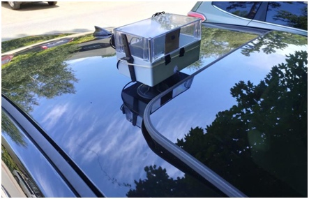
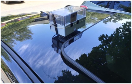
The mobile webcam was mounted on the top of our private vehicle through two suction cups while testing the feasibility and reliability of our system. Figure 15 shown below is the setup of the system. However, it was designed to be implemented on the Island Explorer Service, a public transportation system with ten routes linking hotels, attractions, campgrounds and visitor center on Mount Desert Island. We chose Loop Road (one of Island Explorer’s routes) as our simulated route since it contains nearly all the most crowded destinations in the park (Visitor Center, Sieur de Monts, Sand beach, Thunder Hole, Jordan Pond).
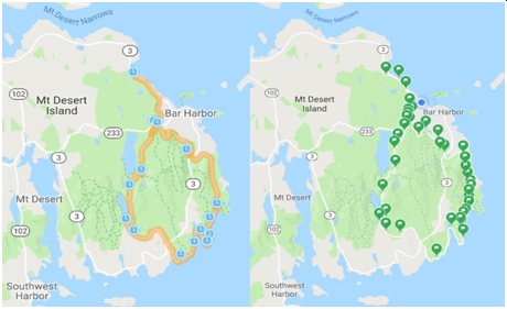
To determine the locations of the places that needed to be monitored, we used the Park Loop Road and the Island Explorer route. We recorded 32 locations along the Park Loop Road route. These locations included road intersections, parking lots and entrance, trailheads, Hulls Cove Visitor Center, and Carriages of Acadia. Figure 16 below is the comparison of the Park Loop Road route and the GPS locations where we chose to capture images. Since the Island Explorer, and our testing vehicles, would not pass exactly the same point every time, we set a configurable radius of 10 meters for each coordinate. Once the vehicle entered this range, the camera would capture an image. Those images were stored in the internal flash drive and uploaded to the cloud once there was connectivity.
3.4 Objective 4: Create a Prototype Web Page to Display the Images from the Webcam
The purpose of the web page was to display, for the rangers and visitor’s use, the images captured by the webcam. Because the web page would eventually contain images from multiple webcams positioned at parking lots throughout the park, the web page was designed to simulate a future webcam implementation. The web page needed to be simple and clear, especially for those visitors unfamiliar with Acadia National Park.
The goal was to create two web pages: one to represent Current Conditions and the other to represent Past Conditions. Thus, there would be two similar but independent web pages. The prototype web pages, though not functional online web pages, were realistic and could be easily integrated into the official Acadia National Park website in the future.
The next things added to both web pages is route and title. The size, font and color of these characters were exactly the same as the ones on the official website. (NPS, 2019b)

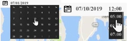
Blow the title, the first thing users would see was a calendar. On the web page for Current Conditions, the calendar would show only the current date. But, on the web page for Past Conditions, the calendar would be clickable and users could choose a date from the past.
In addition to the drop-down calendar navigation, an Acadia map is displayed. There are 15 icons on the map, representing the 15 primary parking lot locations in the park. On the left of the map appears a search box that includes the names of the parking lot locations. This was important since new visitors may not be familiar with the parking lot locations. The search box could be closed and removed from view if necessary.
Source: Implementation and Design of Webcam Systems for Traffic Monitoring in Acadia National Park